If you’ve ever pulled up a FEMA flood map for your address, you’ve probably seen a code like “AE” or “VE” and had no idea what it actually meant for your home. These designations aren’t bureaucratic noise – they determine whether your mortgage lender requires flood insurance, what your premiums look like, and even how a home can legally be built or rebuilt. And the codes that show up most often depend heavily on where you live. Long Island’s coastline and the Gulf Coast both carry serious flood risk, but the specific zones – and what they mean for homeowners – aren’t identical.
What FEMA Flood Zones Actually Mean
FEMA’s Flood Insurance Rate Maps divide land into zones based on flood probability. According to FEMA, high-risk flood hazard areas – called Special Flood Hazard Areas – are defined as land that would be inundated by a flood event with a 1% chance of occurring in any given year, commonly known as the “100-year flood.” These high-risk zones are labeled with codes starting in A (Zone A, AE, AO, AH, and others) or V (Zone V, VE). Moderate and low-risk areas are labeled Zone X, covering the area between the 100-year flood boundary and the less severe 500-year flood boundary.
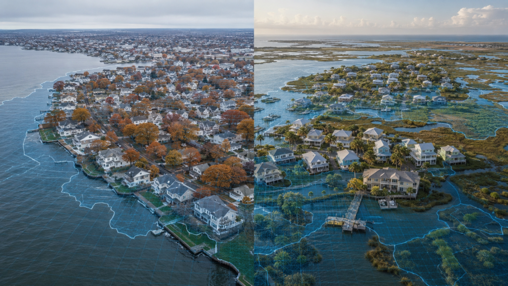
The single most important distinction for coastal homeowners is between A-zones and V-zones. A-zones reflect flooding from rising water – rivers, bays, and storm rainfall. V-zones add wave action on top of that: coastal areas where storm surge combines with waves three feet or higher, capable of undermining foundations and shearing walls off buildings. That wave-action risk is exactly why V and VE zones carry the highest insurance premiums FEMA assigns, and why they require different construction standards than inland flood zones.
Long Island’s Flood Zone Reality
Long Island’s coastline – particularly the South Shore facing the Atlantic and the bay communities along the Great South Bay – includes a meaningful mix of both AE and VE zones. Nor’easters and the occasional hurricane push storm surge into these areas, and the barrier islands protecting the South Shore create the kind of wave-exposed, velocity-zone conditions VE designations are built for. Homes set back from the immediate waterfront, including much of low-lying Nassau and Suffolk County, more commonly fall into AE zones – still mandatory-insurance territory, but without the wave-action building requirements VE zones carry.
This is one of the reasons water damage assessment after a coastal storm on Long Island often needs to account for two different damage mechanisms at once: standing water intrusion from surge, and structural stress or breach damage from wave action closer to the shoreline. Storm damage recovery crews working immediate waterfront properties are frequently dealing with a different scope of damage than crews working a flooded basement a mile inland – even during the same storm.
How the Gulf Coast Compares
Gulf Coast communities, including the Mobile, Alabama area, face a similar A/V zone split – but driven by hurricane storm surge rather than nor’easters, and often across a wider geographic footprint. The Gulf Coast’s flat, shallow continental shelf allows storm surge to push unusually far inland compared to steeper coastlines, which means VE-zone conditions can extend well beyond what most people picture as “beachfront.” If you’re in the Mobile, Alabama area specifically, Mobile AL Water Damage has a closer look at what that storm surge exposure looks like for Gulf Coast homeowners and how it shapes hurricane prep.
The underlying flood zone system is identical nationwide – Long Island and Mobile both use the same AE, VE, and X classifications – but the storm types driving those classifications, and how far the high-risk zones extend inland, differ by region.
The Zone X Trap
One detail that catches homeowners off guard in both regions: being outside a high-risk zone doesn’t mean being outside flood risk. FEMA’s own data shows a significant share of National Flood Insurance Program claims come from Zone X properties – areas not federally required to carry flood insurance. Storm drainage failures, unusually intense rainfall, and outdated map data can all produce real flooding in a property that maps as “moderate” or “minimal” risk. This applies equally to a Long Island home a few blocks from the water and a Mobile, Alabama property well inland from the immediate coast.
For Long Island homeowners specifically, that risk often shows up as basement flood repair calls in neighborhoods that never appear on the high-risk flood map – groundwater and storm drain backups don’t always follow FEMA’s boundaries.
How to Check Your Own Flood Zone
You don’t need to guess which zone your property falls into. FEMA maintains a free Flood Map Service Center where you can enter any US address and see the current flood zone designation, map panel, and effective date. If your property does flood and you’re dealing with standing water, emergency water removal and prompt structural drying matter regardless of which zone you’re technically mapped in. You can look up your address and review official flood zone and insurance program details directly through FEMA’s flood insurance resources.
The Bottom Line
FEMA flood zone codes look cryptic, but they boil down to a simple question: is your property at risk from rising water alone (A-zones), rising water plus wave action (V-zones), or neither in any federally mapped sense (X-zone)? Long Island and the Gulf Coast both carry meaningful exposure to high-risk zones, just driven by different storm systems. Knowing your specific zone – not just assuming based on how close you are to the water – is the first step to understanding your real flood insurance and restoration needs.
Leave a Reply